 |
|
|
Route DeterminationIntroduction Line Characteristics Common to All Routes The Focus of This Section Queen St. Alignment Proposed Route Arguments in Support of a Queen Alignment Arguments Against a Queen Alignment Rail Lands Alignment Proposed Route Arguments in Support of a Rail Lands Alignment Arguments Against a Rail Lands Alignment Preferred Routing of Queen vs. Rail Lands Alignment Queen/Roncesvalles Alignment Proposed Route Arguments in Support of a Roncesvalles Alignment Arguments Against a Roncesvalles Alignment GO Weston Alignment Proposed Route Arguments in Support of a GO Weston Alignment Arguments Against a GO Weston Alignment Preferred Routing of Queen/Roncesvalles vs. GO Weston Alignment IntroductionIn recent years, planning for the Downtown Relief Line has taken shape less in the planning offices of the City and the TTC, and more in the form of fantasy transit maps on the internet. Much debate has occurred over how the subway should be aligned, with fifty pages of discussion occurring on one forum alone (ref. urban toronto). After serious consideration of all arguments, this section weighs the evidence in favour of two major alignments, and two sub-alignments. Queen St. vs. the Rail Corridor, and Queen/Roncesvalles vs. the GO Weston Corridor. Line characteristics common to all routesThough this report will analyze how the subway should go through Downtown Toronto, as well as the specific routing on the west end, there are certain factors that will be common to any route chosen. Station placement cannot be close together, such as on the Bloor-Danforth line. If this line is to act a Downtown Relief Line and convince passengers to transfer onto it rather than at Yonge, their trip needs to be quicker than it would be along Yonge. If stop frequency is similar to Bloor-Danforth, the distance traveled and stops made would be the same, meaning there would be no time savings and the incentive to switch lines is minimized. Furthermore, station cost is a large part of construction cost. On the Spadina extension, six new stations are estimated to cost $807 million, or a little under $135 million each. A station is roughly 152.4 metres in length8, which works out to approximately $883 million per kilometre of station track, while tunnelling, special structures, and operating systems (again based on Spadina estimates) work out to $76.3 million per kilometre. This does not include property costs, which would be even higher in the downtown area. This means that a reduction of stations can have a huge amount of savings on the total cost of the line. Finally, stations are usually built as “Cut and Cover”, meaning the road would have to be torn up. Minimizing stations would minimize the amount of disruption during construction of the line. The connections to the Bloor-Danforth route would also be the same, namely Dundas West in the west and Pape Station in the east. Dundas West has always been used in plans of the downtown relief line, as it is directly north of an important commercial street (Roncesvalles) that the line can run under, and it is beside the GO Weston corridor, which has numerous advantages including potentially cheaper construction by using the right-of-way, future expansion northwest along that route, and a connection to GO train service. In the east, Pape Station may be a departure from the original planning of Donlands, but it adds the advantages of a more logical northerly extension, a continuous north-south alignment on Pape if the subway gets extended further north, and a more westerly location allowing more people to transfer to it en route downtown. If the line only goes as far as Danforth rather than Eglinton, Pape provides a direct connection to the proposed Don Mills LRT so those passengers need not make extra transfers at Pape. Finally, routing from Pape Station to Queen St. and the CN Kingston railway junction would be identical in both alignments; having a cheap, potentially above ground route that hits many important roads and runs on a diagonal would save time on the trip downtown. The focus of this sectionWhile it is a certainty that the route would be expanded north of Bloor-Danforth, especially in the east where a connection to the Eglinton LRT would be vital in taking ridership off the Yonge subway, routing of these sections of the line is less contentious, and it is generally accepted that Don Mills would be the logical routing of an extension north from Pape, while the GO Weston Corridor provides a logical route north of Dundas West. Because these routes have a general expansion plan where only small technical details would need to be worked out, they are not included in this section. This section will focus on the benefits of a Queen Street routing vs. a more southerly routing along and near the Rail Lands, as well as routing the subway up Roncesvalles or up the GO Weston Corridor. Queen St. alignmentProposed routeThe proposed Queen Street subway route would be a simple line tunnelling under Queen from the CN Kingston tracks (at approximately DeGrassi St.) to Dufferin, where its routing is contingent upon a decision of the Roncesvalles vs. GO Weston routing. The length of the line would be constructed using Tunnel Boring Machines (TBM’s) and a cut and cover technique at stations. Stations would be located at Queen and Broadview, Queen and Parliament, Queen and Jarvis, Queen and Yonge (Queen Station), Queen and University (Osgoode Station), Queen and Spadina, Queen and Bathurst, Queen and Dufferin, and optionally at Queen and Strachan. This section of the route would total 7 km. Arguments in support of a Queen alignment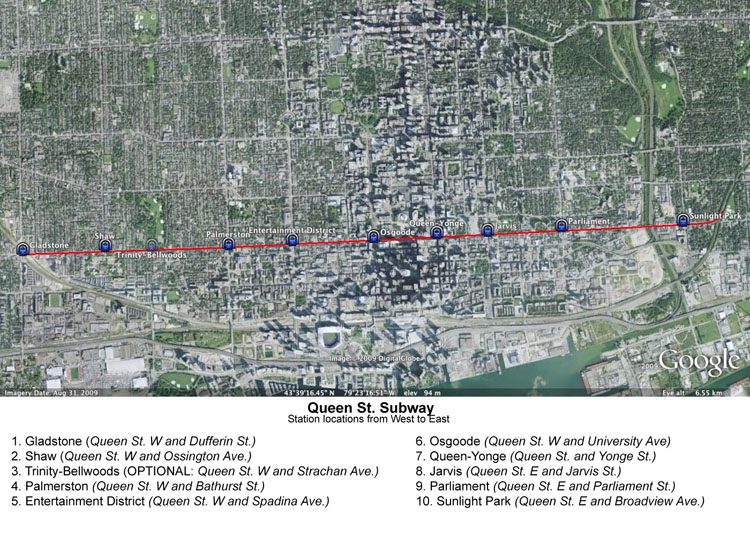 A Map of the Proposed Queen St. Routing Queen St. has been one of the most important thoroughfares in the City of Toronto’s history and has had proposals for a subway underneath it dating back as far as 1909; it was seriously considered as Toronto’s first east-west subway before Bloor-Danforth was chosen18. As one of Toronto’s most important streets, it has always had a very high level of transit ridership, undoubtedly enough to support a subway. The 501 Queen Streetcar had 43,500 boardings per day in the 1997 operating year, the last year the data was made public. This was good for the fifth highest ridership out of surface routes in the system, and this despite severe problems due to traffic congestion that hamper the route147,148. Moreover, Queen ridership has shown historically that it can be much higher than current levels. Combined ridership on the Queen car, along with routes that have since merged into the 501 (Long Branch and Kingston Rd.) had a ridership count of over 80,000 in 1980110. Since then, despite a general increase in ridership levels, the ridership on the line has dropped dramatically. According to Steve Munro’s analysis, it is due to unreliable service and decreased frequency. If a subway were to be constructed, it is almost certain much of that ridership would return. In a 2003 study, Harvey and Mirons estimated that a Queen subway would see between 190,000 and 280,000 passengers per day, as a result of current ridership from a fraction of the Queen and King streetcars, passengers transferring from the Bloor-Danforth line, and new riders. In terms of daily riders per kilometre, if one were to split Union ridership in half between University and Yonge, and take the average estimate of riders siphoned from other lines by the Queen subway in the Harvey and Mirons study off those lines, the line would rank as follows80,147
There is no doubt given the above that the Queen subway would be tremendously successful. As well as established ridership, the line has major trip generators along the route such as the Eaton Centre, City Hall, the Canadian Opera Company, the Queen West shopping district, and the West Queen West entertainment district. Finally, routing along Queen would add the benefit of simplicity. There would be no need to worry about tunnelling under buildings or going to excessive depths, as the entire route would be directly under the street. This also allows the option of cut and cover construction for the entire route to decrease costs, however the cost savings must be weighed against the potential damage to businesses along Queen if the street is out of commission during the construction of a cut and cover line. Arguments against a Queen alignmentThere are a number of concerns regarding a Queen St. routing of the Downtown Relief Line. First, because the stop spacing would need to be relatively far apart for purposes of speed and cost, local service on Queen St. would need to be maintained, similar to how the Yonge Bus north of Davisville and the Sheppard East bus continue to provide service on those lines where stop spacing is a greater distance apart. If local service needs to be maintained, two problems arise. One is that it results in a duplication of service, and it comes into question whether those resources are put into good use. More importantly, the local service would not run at the frequency of the current service, as ridership would not be nearly as high. For example, 97 Yonge buses run at a frequency of once every 15-30 minutes, and 85 Sheppard East buses run once every 15-20 minutes148. At these levels of frequency, retail stores that find themselves positioned mid-block that would continue to rely on streetcar service rather than subway service may see a reduction in patrons. Because Queen is a retail-heavy street, businesses mid-block may not be the only ones to suffer. Cut and cover construction is the usual method of construction used to build any stations along the line, meaning Queen would have to be severely torn up at many intersections. At those intersections, businesses would see a significant drop in traffic. During the construction of the Canada Line’s cut and cover segment along Cambie Street in Vancouver, businesses saw a reduction in sales of an average of 36%134. However, Cambie, even at its thinnest point, is still six lanes wide. During cut and cover construction, at least a few lanes can continue to operate. Cut and cover on Queen St. would require a full closure of the road. The impact this would have on businesses could be very severe. Queen also has a fairly limited development potential, due to its historic status. Though designated in the official plan as an “Avenue”, land to its north are designated as stable neighbourhoods, and though the secondary plans for the Garrison Common North, King-Spadina, and King-Parliament regions allow for growth, all are very sensitive to historic preservation, limiting the potential for new development143. To emphasize this, though zoning can be modified, current zoning along Queen St. allows a density of no more than CR3 except in the area bounded by Simcoe to Jarvis, which is already largely built up. For development to occur along Queen Street, it is no doubt possible, but much more difficult compared to a more southerly routing of the subway line. Another disadvantage to Queen is its location relative to the Financial District. It may be too far north to convince passengers heading there to use this subway, when the Yonge line can drop them off at King or Union, which are both potentially closer to their final destination. Lacking a connection to Union also means that connectivity between TTC and GO is more limited than it could be if the line was placed further south. Finally, the major trip generators along Queen are not necessarily geared towards having a new subway needed to serve them. Eaton Centre, City Hall, and the Canadian Opera Company are already well served by subway stations, and the areas of Queen West and West Queen West are too large to be fully served by one station, and would be better served by streetcar service anyway to accommodate their full length. Rail Lands alignmentProposed route A Map of the Proposed Rail Lands Routing The proposed Rail Lands subway routing would continue along the CN Kingston route south of Queen to across the Don River in an open cut, with a bridge over the Don. After crossing the river, the subway would begin to tunnel under the railway and follow along Mill St. The subway would then continue by use of TBM’s to Parliament and Mill, where it would continue west as cut and cover construction along the Esplanade. At Jarvis the line uses a Tunnel Boring Machine again to continue west, tunnelling under some low-mid density properties to approximately Wellington and Scott, where it continues west along Wellington, to Bay. From Bay, the line curves southwest along a route deemed easiest to tunnel along due to building foundations and garages, to a point around Bremner and Simcoe. The line would then tunnel west along Bremner/Fort York Blvd. where it would curve slightly north to meet the railway lines. The subway would then continue tunnelled west under the CN Oakville railway lines, to the southern side of the GO Weston lines, where it continues to tunnel along the GO Weston lines northwest to Queen and Dufferin, where its routing is contingent upon a decision of the Roncesvalles vs. GO Weston routing. Stations would be located at the CN Kingston sub and Queen St., Mill St. and Cherry St., Mill St. and Parliament St., Lower Jarvis and The Esplanade, Bay and Wellington (With underground transfers to St. Andrew, Union, and King), Bremner and Rees, Bremner and Spadina, Bathurst and Fort York, GO Weston and Strachan, GO Weston and King, and Queen and Dufferin. This section of the route would total 7.8 km. Arguments in support of a Rail Lands alignmentA Rail Lands routing of the Downtown Relief Line would bring high-order transit to many new, dense, developing neighbourhoods that currently lack reliable service. In the western end, it would go through Liberty Village, which is a transit-friendly mid to high density neighbourhood currently lacking any service other than the King streetcar on the north end of the neighbourhood96. This routing would also bring the subway through Cityplace, a residential neighbourhood consisting of 7,500 units and street level retail, making it one of the densest neighbourhoods in Toronto35. A stop at Rogers Centre would serve Rogers Centre, The Metro Toronto Convention Centre, and the CN Tower, three major destinations for citizens and tourists that would ensure the line is well used even outside of rush hour. A stop at Wellington and Bay would be the densest subway station in the subway system, and the closest stop to the Financial District, convincing workers to use the Downtown Relief Line as opposed to Yonge. In the east, the neighbourhoods of St. Lawrence and The Distillery District are served, as well as the West Don Lands, which although currently under construction, by the point of construction of this subway will be complete and contain 6,000 units of housing166. There is no doubt there are many significant trip generators and dense transit-oriented neighbourhoods along this route. This routing would also bring the subway much closer to the East Bayfront and Port Lands neighbourhoods, other areas that are considered to be Regeneration Areas by the City of Toronto and will have dense, transit-oriented development. The East Bayfront community will house 10,000 residents and 8,000 jobs, while the Port Lands will hold 19,400 residents and 792,000 m2 of employment space49,116. A short trip on an LRT running along Cherry St. will bring residents of these areas to the Cherry St. station. As well as providing transit to major, high density neighbourhoods, a Rail Lands routing would potentially convince more rush hour commuters to switch to the line than a Queen line would, as a stop at Bay and Wellington would be much closer to the Financial District. Additionally, this stop would provide a transfer to three different stations, Union, St. Andrew, and King, which would disperse transfer crowds evenly so as not to overload any one transfer point. Each station would be no more than a three-minute walk. This route would provide greater connectivity with the GO network with a connection at Union. The final advantage to this line is the majority of stations are not located in an area that has a high concentration of retail depending on the street. Though traffic disruptions would still occur, they are less likely to cause severe long-term harm to businesses en route than the Queen route would. Arguments against a Rail Lands alignmentThere are two major downsides to the Rail Lands routing. The first is that because it is not replacing or supplementing an already existing route such as Queen, it is more difficult to ensure that ridership would be existent. Though it may seem very likely with several dense neighbourhoods and trip generators, as well as transfer points for the Queen and King streetcars to shorten the trips of those who are riding those, it will always be easier to justify replacing an overcrowded line that is constrained by traffic than to create a new line with no established ridership pattern. The Rail Lines routing therefore has more risk associated with it than a Queen St. routing would have. The bigger downside has to do with feasibility and cost. Though several segments of the line can save money by being constructed as cut and cover or even at grade, the section between Bathurst and Jarvis will have to be very deep in order for the underground train to be able to get under several office buildings to the station in the Financial District. At this point of the city, you would also have to worry about the water table and account for that during construction and operation. This is not an impossibility, as Montreal has stations as deep as 29.6 metres underground104, and New York City has a station 60 metres underground130. Both of these are well below sea level. Still, it is an engineering concern and will likely at least offset the cost savings from the sections of the line that are to be built cut and cover and at grade. Additionally, the depth of these stations should be considered when factoring in time savings, as having to travel up four to six escalators to get to the surface would add at least a few extra minutes to the trip that a station just below ground level would not have a concern with. Preferred routing of Queen vs. Rail Lands alignmentBased on the reasons presented, it is my belief that the benefits of the Rail Lands routing outweigh the benefits for the Queen routing, and similarly the drawbacks are less. I believe the line has a greater potential for success using the Rail Lands alignment, and will be basing planning of the line on the Rail Lands alignment. Queen/Roncesvalles alignmentProposed route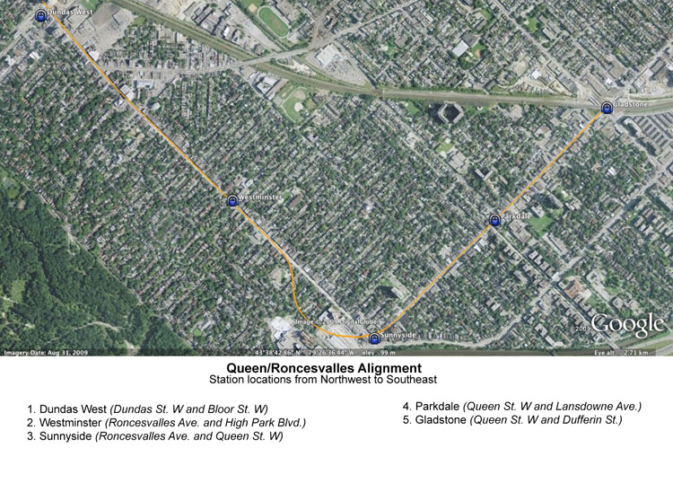 A Map of the Proposed Queen/Roncesvalles Routing The proposed subway route west of Dufferin Street with the Roncesvalles alignment would tunnel under Queen from Dufferin to just east of Roncesvalles, where the subway begins to curve north, tunnelling under the TTC’s Roncesvalles carhouse, and some houses on Marion St. and Pearson Avenue before realigning underneath Roncesvalles. This is necessary in order to provide a satisfactory turning radius for the subway trains, while still providing room for a station at Queen and Roncesvalles. The subway then tunnels north on Roncesvalles, where it joins up with Dundas, and connects to Dundas West Station. The length of the line would be constructed using Tunnel Boring Machines (TBM’s) and use the cut and cover technique at stations. Stations would be located at Queen and Lansdowne, Queen and Roncesvalles, Roncesvalles and High Park Blvd., and Bloor and Dundas St. W (Dundas West Station). This section of the route would total 3.7 km. Arguments in support of a Queen/Roncesvalles alignmentRouting the subway through Parkdale and up Roncesvalles has a number of obvious benefits. The neighbourhood of Parkdale has one of the highest rates of transit usage in the city12, yet relies on the Queen Streetcar, which is known to be fairly unreliable. There are several high density apartment buildings along Jameson Avenue which would see an obvious benefit from having a quick walk to a subway station. This routing would also bring the subway much closer to St. Joseph’s Hospital. The bigger benefit to this routing is the transit interconnectivity seen from the station located at Queen and Roncesvalles. Because this station would be very near the CN Oakville sub, a new GO Train station could be constructed here which would allow passengers using the Lakeshore West GO line to transfer to the TTC’s subway network at a point west of Union. This would provide the benefit of a faster trip to passengers whose destination is ultimately west of Union so there is no longer a need to double back during their journey, and it also provides the benefit of relieving crowding at Union Station as some percentage of passengers would migrate to the TTC at Sunnyside rather than Union, acting in a similar fashion to Dundas West only on the more often used Lakeshore line. Arguments against a Queen/Roncesvalles alignmentSimilar to the difficulties posed east of Dufferin on a line that would go along Queen Street, the devastation caused to businesses along Queen during construction could be quite significant. The heart of Parkdale at Queen and Lansdowne/Jameson would have to be closed completely, meaning traffic and streetcar service could not serve the area. A similar problem would occur on Roncesvalles Ave., which also is not wide enough to allow traffic to pass by during cut and cover construction of the stations. The engineering of the curve from Queen to Roncesvalles may be difficult, and property acquisition may need to take place in order to make the curve wide enough to accommodate a station at Queen and Roncesvalles, which would be the most important station on this route as that is where the line would connect to the GO network. In fact, due to this curve creating a station at Roncesvalles and Queen may not even be possible. Because of this technically challenging curve, as well as having to tunnel the entire length of this route, it is likely that this choice of routing would be substantially more expensive than the alternative, which can run partially at grade and does not require a significant amount of property acquisition. GO Weston alignmentProposed routeThe proposed subway route west of Dufferin Street with the GO Weston alignment would remain at grade from Queen and Dufferin along the GO Weston corridor before entering a tunnel just south of Bloor to connect with the Bloor-Danforth line at Dundas West station. Stations would be located at the GO Weston line and Lansdowne, the GO Weston line and Dundas St. W, and Bloor and Dundas St. W (Dundas West Station). This section of the route would total 2.6 km. Arguments in support of a GO Weston alignment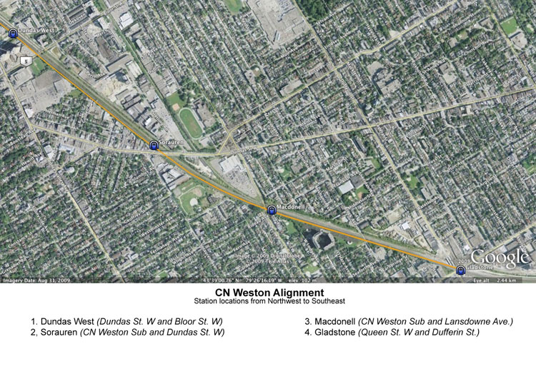 A Map of the Proposed Rail Lands Routing The benefits to a route that follows the GO Weston corridor are significant: lower cost, saved travel time, and minimal disruption during construction. Because much of the line would be at grade, it is likely that this route would be notably cheaper than the alternative that travels along Queen and Roncesvalles. Because this line is approximately a kilometre shorter than the alternative route with one fewer stop along it, it would also be a slightly quicker trip, saving approximately two minutes over the alternative route. Finally, given that construction occurs in a railway corridor, there is no concern of retail stores losing business as a result of street closures. Construction may pose delays to trains, but no major streets would need to be closed down. Arguments against a GO Weston alignmentA Weston routing would not pass any trip generators. Unlike the Queen/Roncesvalles routing where both the Sunnydale and Parkdale stops provide great use in terms of network connectivity and a dense neighbourhood to support ridership, following the GO Weston corridor is unlikely to generate significant ridership as a result of the stations on the line. Similarly, the lack of a transfer to the GO network squanders the opportunity to have the subway line interact with the Lakeshore GO line andtransfer passengers between the networks earlier than Union Station. Preferred routing of Queen/Roncesvalles vs. GO Weston alignmentUnlike the debate between Queen St. and the Rail Lands, this is a much harder decision to make. There is little doubt that the Queen/Roncesvalles route would serve more people, and have a tremendous benefit of a connection to the GO network, but whether that is worth the extra cost as well as the issues caused by construction is a legitimate concern. Given the radius required to curve the track up Roncesvalles, it is questionable whether a station at Queen and Roncesvalles to connect to the GO line could even exist. I believe that ultimately it is important to gauge the opinions of the residents and businesses of Parkdale to see if they believe the benefits of the subway are worth the headaches of construction, especially given the fact that regardless of which route is chosen, a stop at Queen and Dufferin is no more than a ten minute walk from the centre of Parkdale. Because of this, I believe it is not worth the extra cost and the potential damage done to both Queen St. W and Roncesvalles during the construction of the line, and thus will use the GO Weston routing in my analysis. |